“Mark, Traveler, this humble stone”: Quaint and Curious Epitaphs of Copp’s Hill Burying Ground

By Shelby Wolfe, Reader Services

I find a visit to any of New England’s burying grounds fascinating year-round, but I consider treading among slate gravestones and timeworn monuments in October a quintessential New England experience. The leaves turn and fall, beautifully marking a transition from livelier months to the eventual stillness of winter. It’s a fitting setting to consider the lives and deaths of those memorialized on surrounding grave markers. In Historical Sketch of Copp’s Hill Burying-Ground with Descriptions and Quaint Epitaphs, published in 1909, John Norton provides an overview of Copp’s Hill in Boston and the burying ground’s gravestones. Norton begins with a history of Copp’s Hill, spanning its early days as “the North burying ground” through a time “when the well-to-do of Boston dwelt largely in the North End” to the end of the burying ground’s growth around 1832. The second half of this publication includes photographs and epitaphs of select gravestones and monuments.

Hull Street Entrance, Copps Hill Burying Ground


As I read through this Historical Sketch, I realized I neglect to spend as much time as I should to pause and read headstones as I walk through a graveyard. It’s a shame, because whether you appreciate some blunt wisdom from the grave or simply enjoy an eerie epitaph, these gravestones have you covered. Thankfully, John Norton mitigates my neglect with this compilation of “old epitaphs, many of them, as is usual in old burying-grounds, quaint and curious, some incoherent and ungrammatical.” Reading these lines on paper might not have the same effect as seeing them inscribed on their intended medium, but I found this publication a handy tool for noticing themes and considering intentions of particular inscriptions.

Copps Hill Buyring Ground. (Central Part.)


Norton includes his own commentary on certain epitaphs. He remarks, “Doubtless the oddest and most puzzling is that over the grave of Mrs. Ammey Hunt, who died in 1769. We have no clue to the neighborhood gossip hinted at in these peculiar lines:

A sister of Sarah Lucas lieth here,

Whom I did Love most Dear;

And now her Soul hath took its Flight,

And bid her Spightful Foes good Night.


Norton continues, noting an “even more amusing…tradition connected with the following conventional stanza” on the stone of Mrs. Mary Huntley:

Stop here my friends & cast an eye,

As you are now, so once was I;

As I am now, so you must be,

Prepare for death and follow me.


This reminder is a common theme of Copp’s Hill epitaphs, some phrased more motivationally than others:

Susanna Gray, July 9, 1798,––42.

Stranger as this spot you tread,

And meditate upon the Dead;

Improve the moments as they fly,

For all that lives must shortly die.


Mrs. Mary Harvey, died May 2, 1782, aged 63:

Mark, Traveler, this humble stone

‘Tis death’s kind warning to prepare

Thou too must hasten to the tomb

And mingle with corruption there.


Mrs. Hariot Jacobus, died, May 27, 1812, aged 20:

Stop here my friends as you pass by,

As you are now, so once was I;

As I am now, so you must be,

Therefore prepare to follow me.


Others take a more resigned, if not foreboding, approach:

Mrs. Mary Hughes, d. in 1765, aged 46:

Time, What an empty vapour t’is,

            And days, how swift they flay:

Our life is ever on the Wing,

            And Death is ever nigh.

The Moment when our Lives begin,

            We all begin to die.


Mrs. Sarah Collins, died March 29, 1771, aged 62:

Be ye also Ready for you

Know not the Day nor hour.


Many epitaphs of younger women and children express themes of virtue and youth, imagery of fading flowers:

Miss Mary Fitzgerald, died Sept. 30, 1787, aged 19:

Virtue & youth just in the morning bloom

With the fair Mary finds an early Tomb.


John S. Johnson, died Sept. 9, 1829, aged 6:

See the lovely blooming flower,

Fades and withers in an hour

So our transient comforts fly,

Pleasure only bloom to die.


Others offer a sort of rational wisdom to console mourners:

Mrs. Deborah Blake, d. in 1791, aged 21 years:

Friends as you pass, suppress the falling tear;

You wish her out of heaven to wish her here.


Mrs. Abigail Cogswell, died Jan. 19. 1782, aged 42:

To those who for their loss are griev’d

This Consolation’s given,

They’re from a world of woe reliev’d

We trust they’re now in heaven.


If you have the opportunity, I encourage an autumn visit to Copp’s Hill and other historic New England burying grounds. While you take in the site and scenery, spend some time considering the lives and deaths of the individuals whose graves are marked. Read what they or their loved ones chose to be inscribed on their stones. For inspiration, historical sketches, and legible transcriptions of “ye ancient epitaphs,” as Norton writes, read more about visiting the library to work with Norton’s Historical Sketch of Copp’s Hill Burying-Ground and related material.


From Fenways Past

By Anna J. Clutterbuck-Cook, Reader Services

Tomorrow, the Massachusetts Historical Society — in collaboration with the Emerald Necklace Conservancy — is offering a walking tour of our neighborhood, the Fenway. In celebration of this unique neighborhood, I have selected a few postcards from our collection that illustrate the Fenway’s gardens, streets, and buildings as they once appeared. The next time you visit the Massachusetts Historical Society, the Museum of Fine Arts, Fenway Park, or the Back Bay Fens, take a moment to look around for signs of our neighborhood as it has grown and changed for the century and more that the MHS has occupied the corner of Boylston and The Fenway.


Since 1912, Fenway Park has been home to the Boston Red Sox and parts of its original brick facade are still visible to visitors and passersby. This postcard dates from 1914 and suggests that the ritual of lining up before the gates open has a long history!


The Back Bay Fens, part of the chain of city green spaces known as the Emerald Necklace, were designed and constructed in the 1890s by the firm of Frederick Law Olmsted. The broad avenues of The Fenway and Park Drive that encircle the gardens, playing fields, and marshlands, were purposefully designed for leisure driving, cycling, and walking.


The two columns at Hemenway St. and Westland Ave. still stand as a gateway to the Fens for pedestrians and drivers alike. If you walk through this intersection today, many of the young trees depicted on this postcard now tower above the street, providing shade to pedestrians and cyclists as they pause for a break in automobile traffic.


Open to the public in June 1876 on Copley Square, the Museum of Fine Arts, Boston relocated to the Fenway in 1909. The Evans Wing for Paintings, depicted here in a fine black and white print, opened to the public in 1915. Today, one of three entrances to the museum opens out onto the Fenway, memorably flanked by the bronze sculptures Night and Day by Spanish artist Antonio Lopez Garcia.


 Across the waters of the Fens from the MFA stands the Kelleher Rose Garden, opened in 1931 and designed by landscape architect Arthur Shurcliff, whose papers are held in the MHS collections.


Beyond the Museum of Fine Arts, along The Fenway, stand “Mrs. Jack Gardner’s Palace” —  the Isabella Stewart Gardner Museum — and Simmons College, founded in 1899 and opened to its first class of 142 students in the fall of 1902. They offered young women degrees in Home Economics, Library Studies, Secretarial Studies, Nursing, Teaching, and General Science.


At the opposite end of the Back Bay Fens from Simmons College stands the Somerset Hotel. Designed by Arthur Bowditch in the 1890s — the same period during which the Massachusetts Historical Society’s 1154 Boylston St. building was under construction — Somerset Hotel still stands today along what remains of Charlesgate Park, the link between the Back Bay Fens and the Charles River Esplanade.


The Esplanade parkland was severed from the Emerald Necklace in the 1950s when Storrow Drive was constructed to ease the traffic congestion to and from downtown Boston. Our final postcard today shows the newly-minted roadway as it snakes passed the now-iconic Hatch Memorial Band Shell, from which the Boston Symphony Orchestra broadcasts its Boston Pops concert every 4th of July.

While the postcard collection at the Massachusetts Historical Society is uncataloged, it is available for research use in the Society’s reading room. The postcards are arranged by geographic location and subject matter, covering Massachusetts, national, and foreign scenes. If you would be interested in accessing this collection please contact the library to arrange a visit.


Major Samuel Selden’s Powder Horn: A Revolutionary Map of Boston

By Allison K. Lange, PhD

We expect to see maps on paper, not on animal horns. Maj. Samuel Selden might have thought this as he etched a map of Boston on his powder horn, which is dated 9 March 1776. During the Revolutionary War, soldiers used animal horns to hold their gunpowder. They filled them at the larger end and funneled the powder into their weapons. Not all militiamen had their own powder horns, so men like Selden carved unique designs on them in order to claim them as their own.

Selden was a member of Connecticut’s Provincial Assembly and became a major in the colony’s militia during the war. He served under George Washington’s direction during the siege of Boston. His powder horn depicts the sites of American fortifications as well as the positions of the Continental Army just before the British evacuated the city.

Even if we did not know Selden’s background, his carvings convey his allegiances. A ship labeled “Amaraca” displays a Continental Union flag. Another flag depicts the Liberty Tree, the tree near the Boston Common where locals met to protest British rule. Alongside his name, Selden also inscribed the words: “made for the defense of liberty.”

Selden’s map is a pictorial map rather than one focused on the area’s geography. His detailed carvings feature individual ships in the harbor and houses lining the Boston neck. Crosshatching adds depth to the water and makes his lettering stand out. In contrast, a 1775 powder horn housed at the Norman B. Leventhal Map Center features a more traditional map of Boston. Instead of pictures, this map traces shorelines. Unlike Selden’s, however, a British soldier carved this powder horn. He inscribed the words: “A Pox on rebels in ther crymes [their crimes].”

1775 powder horn

Photo courtesy of Norman B. Leventhal Map Center.

Just six months after Selden carved his horn, the British captured him at the Battle of Kip’s Bay during their campaign to take control of New York City. The prison’s conditions were poor. Less than a month later, Selden fell ill and died on 11 October 1776.

Selden’s powder horn, as well as that of his British counterpart, is currently on display in the Norman B. Leventhal Map Center’s exhibition at the Boston Public Library. The exhibition, We Are One: Mapping America’s Road from Revolution to Independence, uses maps to explore the events that led thirteen colonies to forge a new nation. We Are One demonstrates that maps, from Selden’s carving to early European maps of the new nation, were central to the revolutionary process. The exhibition features maps as well as prints, paintings, and objects from the Leventhal Map Center’s own collection and those of twenty partners, including the British Library and Library of Congress. Visit zoominginonhistory.com to explore geo-referenced maps from the exhibition.

The exhibition will be on display at the Boston Public Library through November 29, 2015. We Are One then travels to Colonial Williamsburg from February 2016 through January 2017 and to the New-York Historical Society from November 2017 through March 2018.

The Leventhal Map Center also hosts the NEH-funded American Revolution Portal database. Researchers can access maps from the Massachusetts Historical Society, British Library, Library of Congress, and other institutions in one search. Users can download images for research and classroom use. Access these resources and learn more about We Are One at maps.bpl.org/WeAreOne.

Find out more about the Society’s own map collection at their upcoming exhibition: Terra Firma: The Beginnings of the MHS Map Collection, which opens on 2 October. Through 4 September, visitors to the MHS can learn more about the American Revolution with exhibition: God Save the People! From the Stamp Act to Bunker Hill.

Image 1: Selden, Samuel, 1723-1776. [Powder horn scribed by Samuel Selden.] Lyme, Conn., 1776. 1 powder horn: ivory; 37 x 21 x 13.3 cm. Massachusetts Historical Society.

Image 2: Detail of above.

Image 3: E.B., [Powder Horn with Map of Boston and Charlestown]. [Boston], 1775. Scrimshaw horn, 14 x 3.5 x 3.5 inches. Norman B. Leventhal Map Center.

Attention All Cartophiles

By Dan Hinchen

Back in Novermber I posted on the Beehive about the MHS library staff field trip to Worcester’s American Antiquarian Society. The motivation behind the trip was to learn more about the AAS collections, policies, and how their services can benefit our researchers. We, the staff, also selected many other local institutions to visit to gain better understanding of the resources available to our researchers when they need to get beyond our holdings. 

Yesterday, my colleague Kittle and I had the pleasure of visiting the Norman Leventhal Map Center at the Boston Public Library. While there, we learned about their collections (over 200,000 maps), their accessibility (open to the public), and their short history.

The Map Center’s holdings range from the late 15th century all the way up to the present day, from some of the earliest printed maps to modern metropolitan planning maps. The materials are all cataloged online via the BPL Bibliocommons. In addition, the Leventhal Center has over 7,000 items digitized and viewable on their website. And for those that enjoy a more whimsical view of things, they also hold a collection of maps from fiction. These chart the geographies of places like Middle Earth and Narnia, detail the mysteries of Sherlock Holmes, and map out the course of Captain Ahab and the Pequod. These fictional maps are the focus of the Center’s current exhibition. 

After we learned about the public side of the Map Center, the gracious staff also toured us through the background, showing us the secured storage spaces where these important collections are housed and preserved. 

Learning more about the Leventhal Map Center allows now to better direct our own researchers who need cartographic resources that the MHS does not hold. And not only did we get to learn about the wonderful collections but we got to introduce ourselves and meet some of our neighbors. Stay tuned for more installments from our staff site visits to see who we meet and what we find!

Oliver Lofts: Mapping the Traces of a Music Publishing Empire

By Anna J. Clutterbuck-Cook, Reader Services

A couple of weeks ago, my wife and I moved across town from one former streetcar suburb-turned-neighborhood of Boston (Allston/Brighton) to another (Jamaica Plain). A paltry three mile journey as the crow flies, since we live without a car and get around on foot, public transit, or bicycle, this has meant learning new pathways to all of our usual destinations — including the Massachusetts Historical Society. Along these new routes stand traces of Boston’s past, if only you keep your eyes open and know where to look for them.

Bicycling home from work along the Southwest Corridor Park, from Symphony Hall to Jackson Square, last week I happened to notice the brick facade of an old factory building turned residential lofts that announced in the stonework “Oliver Ditson Co.”

Who, I wondered, was Oliver Ditson, and what had his factory once produced? Fresh from reading Alexander von Hoffman’s history of Jamaica Plain, Local Attachments: The Making of an American Urban Neighborhood, 1850 to 1920 (Johns Hopkins University Press, 1994), I knew the Heath Street area had been known for its breweries. Perhaps, I thought, our Mr. Ditson was a brewer. Happily, I work at a place where such questions can often be answered by searching our catalog and going on a historical treasure hunt! A few keystrokes and call slips later, I had discovered that Oliver Ditson and his company were not brewers but, instead, music publishers and retailers here in Boston. Ditson, born in Boston in 1811, began his career working at a bookshop on Washington Street, under the employ of Samuel H. Parker, before launching into the music publishing business in 1835. In 1858 Oliver Ditson & Co. began publishing Dwight’s Journal of Music, one of the most highly respected music journals of the nineteenth century, and was soon expanding into the Cincinnati, Chicago, Philadelphia, and New York markets.

In 1918 a history of the music scene in Boston, published by the Oliver Ditson Company, foregrounded the company’s sparkling new ten-story retail building that still stands today on the corner of Tremont and Boylston Streets, overlooking the Boston Common. “The focus on modern Boston’s shopping activity is at the corner of Tremont and Boylston Streets, where converge the currents of vivid life from hotels, theatres, and subways,” writes William Fisher in Notes on Music in Old Boston. “Within a stone’s throw of this teeming corner … is the splendid new home of the Oliver Ditson Company” (79). From its state-of-the-art heating plant in the sub-basement to its Tiffany show windows, “Victor Talking Machines” department,” and opulent meeting rooms, the Tremont Street headquarters was the company’s public face.


The building that would become Oliver Lofts in 2011 meanwhile, was a late arrival into the company’s holdings. The property did, indeed, begin life as a brewery — though unassociated with Ditson. According to Historic Boston, the Highland Spring Brewery occupied the site until Prohibition brought the American beer industry to its knees. The Oliver Ditson Company then purchased the storehouse, built in 1912 and once used to house casks of ale and porter, and used the building as a print shop and warehouse into the mid-twentieth century.

Thus, one single rehabilitated industrial building I pass by on my evening commute holds within its walls traces of two centuries worth of Boston development.

From Medicine to Music: #8 The Fenway

By Dan Hinchen

Around the Neighborhood – #8 the Fenway

These days, the Historical Society is hemmed in by institutions devoted to the study of music. Our neighbor to the east on Boylston Street is the Berklee College of Music. Around the corner to our southwest the New England Conservatory occupies several buildings. But, in looking through some old photos recently, I found that a very different group once rubbed shoulders with the MHS on the Fenway.

The second iteration of the Boston Medical Library was founded in 1875, thanks mainly to the efforts of the then 30-year-old Dr. James Read Chadwick with tremendous support from the older Dr. Henry Ingersoll Bowditch. Beginning in December 1874, these two men and many other prominent Boston doctors held several meetings and published circular letters to gain support for the founding of a new medical library in the city. Once there was enough support, Chadwick drew up a constitution and by-laws for the new library and, in October of 1875, the Boston Medical Library opened in two rooms at No.5 Hamilton Place in downtown Boston. It would take only three years for the rooms to become inadequate for the Library’s needs.

In February, 1878, the Boston Medical Library Association began making appeals for help in acquiring a new space. The property they purchased was located at 19 Boylston Place, previously both the home of Dr. Samuel G. Howe and a boardinghouse. This spot served as the Library headquarters for the next 23 years until the space was outgrown once again. In his History of the Boston Medical Library¸ Dr. John Farlow noted that “There was no doubt that No.5 Hamilton Place was outgrown in 1878, and No. 19 Boylston Place was outgrown in a still greater degree in 1900. How the library ever continued to exist and serve its members in the overcrowded quarters, seems more or less of a wonder, as we look back on it.”[i]

In May 1899 members of the Library were asked to decide between two parcels of land on which to construct a new building. At the meeting, a committee presented brief statements advocating for either a lot at St. Botolph and Garrison Streets or a lot on the Fenway. Regarding the lot on the Fenway, the committee stated:

On the Fenway we can buy two (or three) lots facing west by south, and next the Historical building. The western light will be very strong on the front. We can build fifty feet front by one hundred deep. The rear is tolerable, but not attractive. The front view is unsurpassed. It will be quiet, clean, bleak. It will appreciate in value of land. We cannot build a symmetrical building, without wells and irregularities. We are limited to seventy feet in height on the front. We may be allowed to carry the rear higher for a book-stack. We must buy a third lot, and keep it wholly or partially unoccupied for side windows and for future growth. We shall have a building twice as long as it is wide, and with a dark centre, unless we have plenty of side windows.[ii]

With a vote of 53 for and 19 against, the Association decided in favor of the Fenway lots. A building committee composed of Drs. John Collins Warren, James Read Chadwick, and Farrar Cobb selected Shaw and Hunnewell as architects. In November 1899, the committee awarded the $86,000 contract for erecting the building to the McNeil Brothers. They also gave contracts for heating, bookstacks, wiring, and an elevator well with room for the machinery. By 12 January 1901, the Library opened to the public with a dedication occurring that evening, just two years after the completion of the MHS’ home at 1154 Boylston Street.

The Boston Medical Library in 1919 at 8 Fenway. A portion of the MHS is seen on the left. What do you think happened to the planned side windows? (“Boston Medical Library” Unknown Photographer, 1919. From the Massachusetts Views collection. Massachusetts Historical Society.)

The Boston Medical Library remained at #8 Fenway for 64 years until the Library closed its doors on 14 June 1965. Over the next two all of its holdings were removed and merged with the collection of Harvard’s newly built Francis A. Countway Library of Medicine. On 16 June, the Countway opened to readers.

On 15 January 1964, the Boston Medical Library trustees agreed to sell their building to the neighboring Boston Conservatory of Music for the price of $300,000. The actual sale did not occur until after the move to the Countway in July 1965, and the Library did not officially vacate the property until 2 September.[iii]

If you are interested in finding out more about the history of the Boston Medical Library you can search our online catalog, ABIGAIL, to see what materials we have relating to it. In addition to several printed volumes relating to the Library, the MHS holds significant collections of materials related to many early members of the Library, including Henry Ingersoll Bowditch, Oliver Wendell Holmes, John Collins Warren, and Charles Pickering Putnam.


[i] Farlow, John W., The History of the Boston Medical Library, Norwood, Mass.: The Plimpton Press, 1918.

[ii] Ibid.

[iii] Garland, Joseph E., The Centennial History of the Boston Medical Library, 1875-1975, Boston: Trustees of the Boston Medical Library, 1975.


“Imposed Planning STOPS HERE”: Fenway in the 1970s

By Anna J. Clutterbuck-Cook

My last post for the Beehive explored the creation, destruction, and potential renewal of Charlesgate Park in the Back Bay neighborhood of Boston. In my continued exploration of the Society’s 20th-century urban history collections, I stumbled across this handmade flyer from the early 1970s calling on residents of the Fenway to protest what they experienced as “imposed planning” in the then-struggling neighborhood.

Fenway Residents broadside

“Fenway Residents, We Ask You One More Time” (Broadsides Collection, [1970] Nov. 3, MHS)

The gathering was organized by the housing task force of the Fenway Interagency Group (FIG), a loose coalition of grassroots social services organizations based in the Fenway neighborhood. What, exactly, were they protesting?

Though tentatively dated 1970, it is likely the flyer was distributed during the spring or summer of 1971, as the Christian Science Plaza was taking shape and the neighborhood around the plaza was filling with new development. A newspaper clipping dated April 1971 and preserved in a Boston Redevelopment Authority (BRA) scrapbook describes the construction in positive, neighborhood-friendly terms:

The first housing development is now under construction along the Church Center perimeter. This project, known as Church Park will be the largest apartment house in Boston. It is planned as a mixed use building with 526 units of housing plus parking and retailing. …In this low and middle income development, 25 percent of the units will go to low income families and the balance will go to middle income families at rents ranging from $110 to $360 per month.

The article goes on to describe the “Wasserman Site,” where the FIG flyer invites citizens to protest, as “320 units of middle income housing plus parking and retailing.” This official story stands in contrast to the flyer’s claims that the development represents “imposed planning,” a “disregard of residents,” and “housing residents can’t afford.”

Which story won the day? The Church Park building and what became Greenhouse Apartments were both constructed and remain standing today. Leasing at prices between $2500-$5000 per month, the units are now two or three times higher than the BRA considers the maximum affordable rent for median-income Boston residents.

Church Park

Church Park from the intersection of Edgerly and Norway Streets (March 2014)

Over forty years after the FIG protest was held, economic inequality remains a central theme in Boston city politics, and the BRA role in neighborhood planning continues to prove controversial as Bostonians debate how to bring economic investment into the city without pushing lower-income residents and workers out of the urban core.

Charlesgate Park, the Bowker Overpass, and Our Changing Urban Landscape

By Anna J. Clutterbuck-Cook

As a transplant to Boston, one of my goals of the past few years has been to develop a better grasp of the topographical history of this tangled, layered city. As the daughter of a cartographer, I was raised to pay attention to the built and wild landscape around me, and also to appreciate how landscapes are ever-evolving. One of the things that fascinates me about Boston as a city is the way in which its landscape is constantly in flux, and yet how every inch of the land and the structures on it contain traces of previous contours, uses, and lives.

Charlesgate
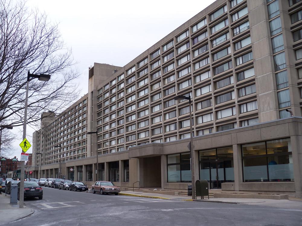
“Intersection of Boylston Street and Charlesgate from the West. Photograph by Anna J. Clutterbuck-Cook, January 2014.”

The Massachusetts Department of Transportation (MassDOT) has recently completed a study of the ramps on and off I-90 turnpike in central Boston. One focus of the study is the renovation or removal of the Bowker Overpass, constructed in 1967 over the much-beloved section of Frederick Law Olmsted’s Emerald Necklace park system known as Charlesgate Park. Charlesgate Park, completed in the 1880s, connected the Fens and the Commonwealth to the Charles River Esplanade. Boston University student Allan Lasser offers an excellent overview of the history of Charlesgate and the overpass in a 2013 article, “Charlesgate: A Palimpsest of Urban Planning” (New Errands, vol. 1 no. 1).

What, you might ask, does all of this have to do with the Massachusetts Historical Society? Well, we are part of this narrative of landscape too. The current home of the MHS, constructed in the 1890s, stands at the top of Charlesgate East. Our reading room overlooks what once would have been the southern entrance to the Charlesgate Park. In this aerial photograph digitized by MIT libraries, one can see the top of Charlesgate Park and the Fens stretching southwest towards Jamaica Pond; the MHS is just visible in the lower left-hand corner.

In the mid 1890s, Boston artist Sarah Gooll Putnam pasted this photograph of Charlesgate Park into her diary:

Putnam diary“Charlesgate Park. Photograph by unknown photographer, circa 1893-1896. Sarah Gooll Putnam Diaries, vol 20, MHS.”

Last week, on my walk to work, I paused with a camera at the top of Charlesgate East and captured some images This is what the southeast corner of Charlesgate Park looks like today. The building that features so prominently in Putnam’s photograph can be seen in the distance beyond the passing school bus.

Charlesgate 2
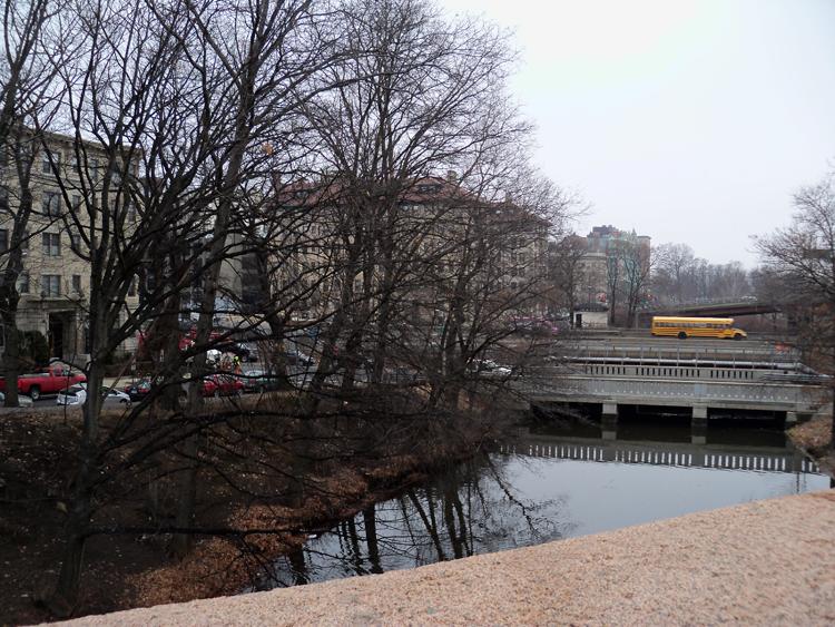
“Charlesgate Park from the corner of Boylston Street and Charlesgate East. Photograph by Anna J. Clutterbuck-Cook, January 2014.”

While some urban planners would argue the Bowker Overpass is an essential pressure valve, easing traffic congestion in and out of central Boston, it is easy to see why city residents and nature-lovers abhor the auto-friendly changes to the neighborhood. In The Paradise of All These Parts: A Natural History of Boston (Beacon Press, 2008), natural historian John Hanson Mitchell scathingly refers to the Charlesgate as a “perfect example” of “all that went wrong in Boston in the 1950s, and in some ways all that has gone wrong in the environment since the invention of the internal combustion engine” (120). Agreeing with him, citizen groups Friends of the Charlesgate and The Esplanade Association are lobbying for MassDOT to remove the Overpass and restore the Charlesgate Park as a pedestrian-friendly link from the Fens down to the Esplanade. Whatever happens, the MHS will stand at the corner of Boylston and The Fenway, bearing witness to the changing landscape around us.

Fenway Garden Society: From Victory Gardens to Historic Landmark

By Emilie Haertsch, Publications


When the United States entered World War II after the bombing of Pearl Harbor, the nation’s food resources were already stretched thin. Once operating at a surplus, U.S. farmers were sending a large portion of their crops overseas to aid the Allies and alleviate the growing food shortage in Europe. With U.S. troops heading to war, there was an ever greater demand for food as only well-fed soldiers could serve at full strength.

In response to the increasing need for food, the U.S. government implemented the Food Rationing Program in 1942, which called on U.S. citizens to conserve their food consumption and avoid waste. In conjunction with rationing, the government also asked civilians to plant “Victory Gardens” and consume the produce they grew. The slogan “Food For Freedom,” originally coined during World War I, was repurposed to great effect.

There is evidence of this very garden movement in Boston’s Fenway neighborhood today. Among the 49 areas obtained for gardens by the Boston Victory Garden Committee, one large plot was established in what is now known as the Back Bay Fens. Area community members could apply for their own plots to aid the war effort, and receive instruction if they were novice gardeners. In order to encourage better gardening and crop yield, Victory Gardeners also held contests and exhibitions.

The gardens remained in this form until the war was drawing to a close and the need for food rationing in the U.S. lessened. In 1944, a group of plot-holding gardeners who feared losing usage of the land assembled with the goal of continuing their urban gardening beyond the war. They established the Fenway Garden Society, and the MHS has their papers in its collections.

The Fenway Garden Society held its first meeting on 15 October 1944, with 23 members in attendance. According to the meeting notes, the society’s object was to “promote the planting and growing of vegetables for home usage.” The society continued to be part of the war effort into 1945, when Chester Bowes of the War Food Administration in Washington, D.C., “wrote stating more food would be necessary.” However, by 1946 the National Victory Garden Commission had dissolved and the society shifted its focus to the general benefits of gardening.

They continued to hold contests to encourage good gardening, giving out small cash prizes and the coveted gold star to winners. They also wrote open letters to gardeners to encourage them to become involved in the society’s work and promote knowledge of gardening.

The Fenway Garden Society often faced an uphill battle in maintaining the piece of land used for the garden plots in what continues to be a highly desirable part of Boston. In one of their first open letters in 1946 they referenced “a petition asking for the gardens for this year, and expressing appreciation for them in the past” and encouraged prospective and current gardeners to sign. There would be many more occasions when the society’s members would have to advocate to maintain their land. Throughout the years, attempts have been made to build hospitals, schools, and parking lots on that land, and it has only been through the Fenway Garden Society’s efforts, and media and legislative support, that the community gardens have remained.

Today the Fenway Victory Gardens are a Boston Historic Landmark. The Fenway Garden Society still exists today and tends the same land in the Fens, which now consists of 500 individual plots cultivated by a diverse group of gardeners.

Fenway Studios

By Dan Hinchen, Reader Services

Continuing a theme that started many months ago, it is time to take a new look Around the Neighborhood for another glimpse of the history that is part of, and surrounding, the MHS. In this installment, let us look just around the corner onto Ipswich Street, where we find the Fenway Studios.

In 1904, a fire at the Harcourt Studios on Irvington St, near present-day Copley Plaza, deprived many Boston artists of their studios and life’s work, some lucky to emerge alive. Almost immediately, members of the Copley Society and St. Botolph Club started collaborating to get a new space designed and built. It took only three months for the group to raise $90,000, through subscriptions, to fund a building and to get land donated.

Built the same year, the Fenway Studios is the oldest continuously functioning building in the United States that was designed and built for use by artists. The building is now on the list of National Historic Landmarks

The studios were built in the Arts and Crafts design, a style that took its cues from the Aesthetic Movement that was in vogue in England at the time. Englishman William Morris summed up his vision for the movement when he said “Have nothing in your houses that you do not know to be useful or believe to be beautiful.” The simplicity of this idea and the implied ambiguity – what constitutes Useful or Beautiful? – have granted the Arts and Crafts movement impressive longevity.

Drafting of the building was done quickly but not without heavy input from the artists that would occupy its space. Many of these original artists had studied in Paris in the late 19th century and, with that as inspiration, came up with four elements that were key to their vision of a new workspace: abundant north light, spacious rooms, convenient location, and affordable rents. The building was thus constructed with each of the 46 studios possessing 12-feet high, north-facing windows and 14-feet high ceilings.

Externally, the building was constructed using clinker brick – bricks that are partially vitrified. When created, the bricks are burned at extremely high temperature which yields denser, heavier, and darker bricks. The resulting pieces are very water resistant but with higher thermal conductivity and therefore lending less insulation.

Though the building is still standing and in use today, according to the National Park Service, as of 1998 it has severe structural problems on the north elevation and, due to possible encroachment by the development of the Turnpike in front of it, the north light that is so vital to artists is under threat.

While the MHS does not hold any records relating specifically to the Fenway Studios, the Society does hold some secondary works relating to the Arts and Crafts movement as well as some pieces created some of the notable artists of the day that would have used the studios, including Charles Hopkinson, Lilian Westcott Hale, and Philip Hale.

Contact the MHS Library to find out more!

Sources

– Brandt, Beverly K., The Craftsman and the critic, Amherst, Mass: Univ. of Mass. Press (2009).

– “Fenway Studios History,” Friends of Fenway Studios, accessed 21 March 2013, http://www.friendsoffenwaystudios.org/about_fenway.php.